Checkerboard Site Guide
Paragliding in the Flathead Valley
revised 4/16/24
Basic Information
Rating: P2/H2
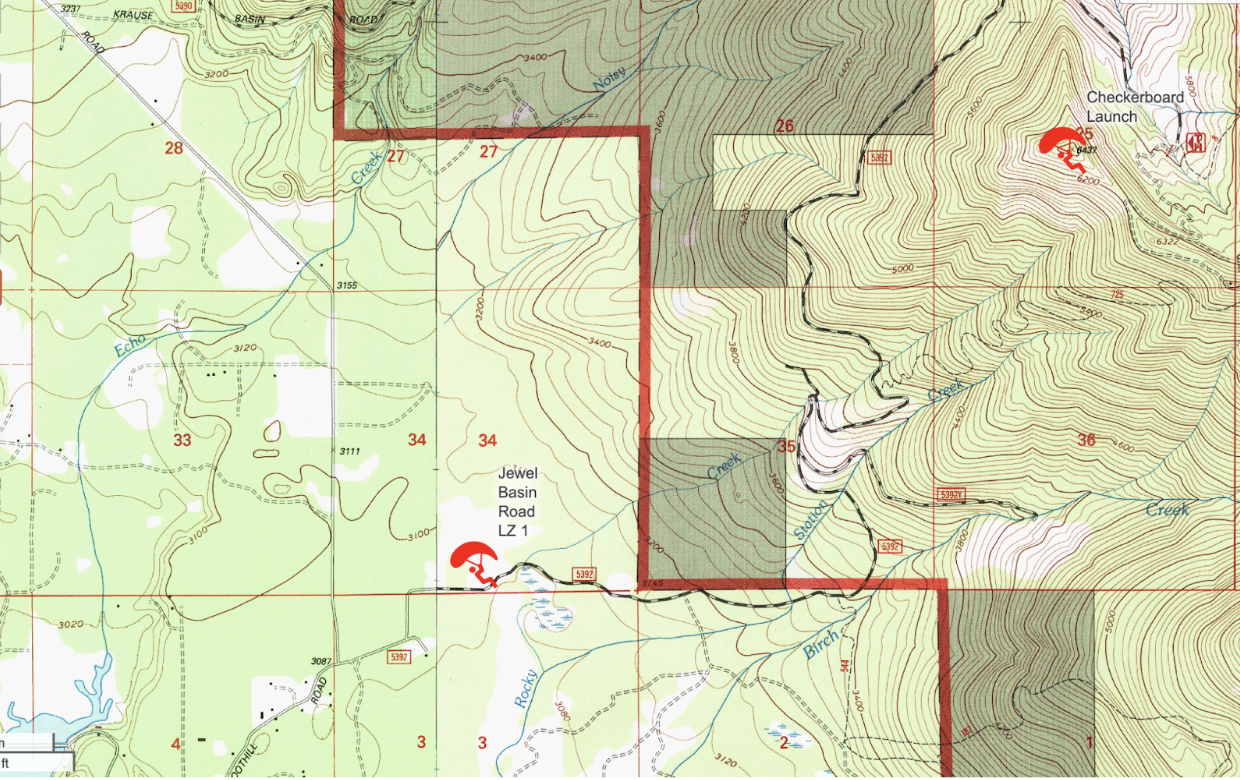
Map of Launch and LZ:
Launch
“Checkerboard”
Elevation: 6,425 ft
Coordinates: 48.16047, -113.95625
Takeoff direction: Southwest
Land manager: USFS
Primary LZ
“Lunch Lady LZ”
Elevation: 3,094 ft
Coordinates: 48.14072, -113.99826
Land Manager: MT Department of Natural Resources and Conservation
Leased by Bill and Linda Stewart of Jewel Basin Road
Description
The “Checkerboard” launch, near Mt. Aeneas, in the Flathead National Forest is the primary hang gliding and paragliding launch in the Flathead Valley. Checkerboard Launch sits on a ridge overlooking the Flathead Valley and Flathead Lake. It offers pilots a range of opportunities, from “sled rides”, X.C. flights, and ridge soaring flights, depending on weather, thermal, and wind conditions.
Flying at the Checkerboard site is sensitive. In recent years increased use, and pilots landing on private property, has created issues with the local community. Please help us protect and maintain this site. Obey all FVSA bylaws.
The recent growth of freeflight in the Flathead Valley led to the formation of the FVSA in 2024. The FVSA is working to protect and expand freeflight in the Flathead Valley.
Checkerboard Launch Parameters
Weather to Fly
Real time Weather information
The Flathead Avalanche Center Maintains a weather station near the summit of Mt Aeneas: https://flatheadavalanche.org/weather/#/station-table/MAEMT
This is useful in getting real-time/ current wind and weather data!
Kalispell airport’s Winds Aloft forecast
Oftentimes the upper level winds are stronger than the wind felt on launch. It is important to know the winds aloft forecast.
Wind
Speed
Minimum: 0mph
Ideal: 6mph
Max: 8mph
Direction
200’-220’
Wind from the southwest is favored
Glide ratio to primary LZ
4.9:1
Launch Access

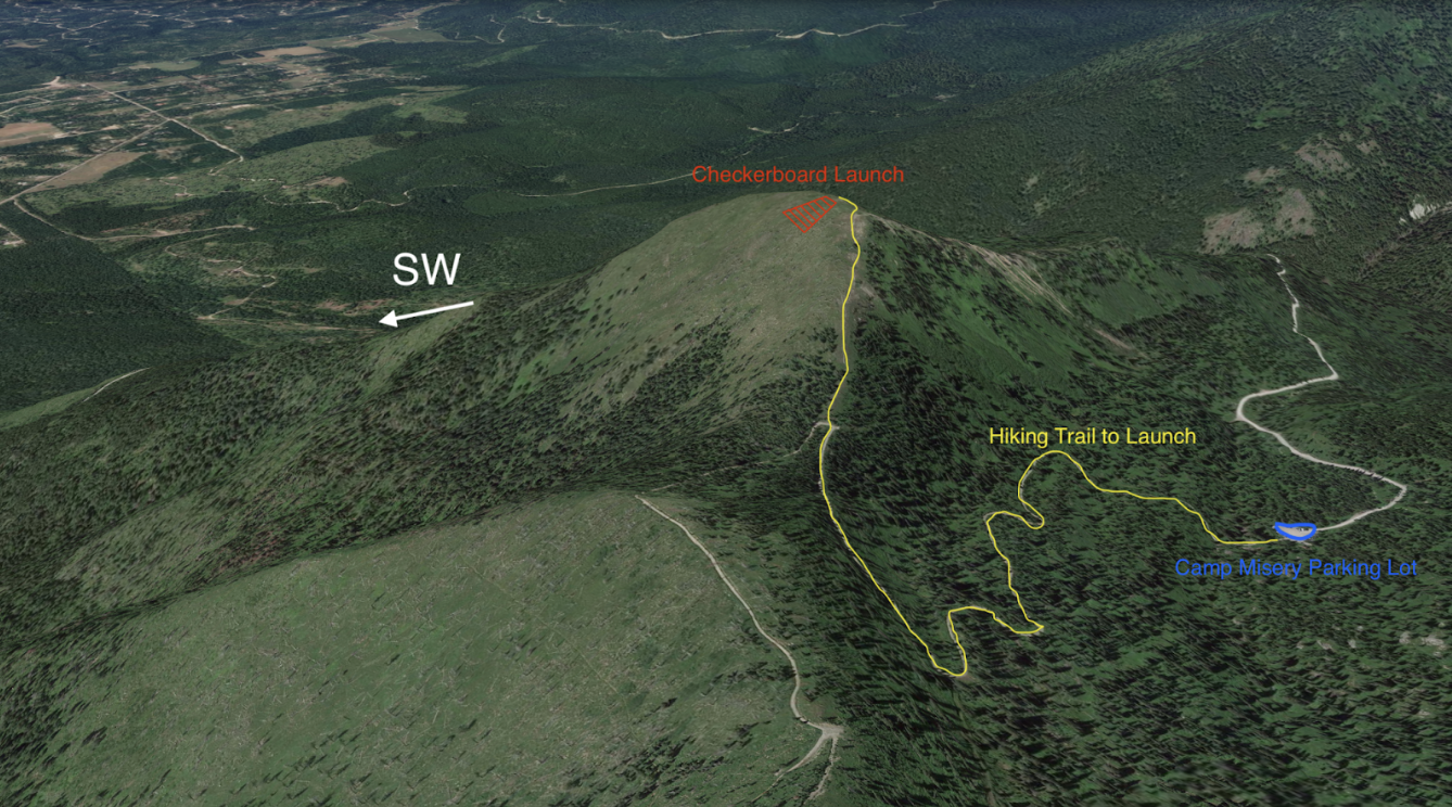
Launch is accessible via foot:
Most pilots access the launch from the “Camp Misery Trailhead”. The trailhead is a 30 minute drive from the LZ parking area. Pilots are encouraged to park at one of the LZ parking areas and share rides to the trailhead as the camp misery parking lot is oftentimes overflowing with vehicles. The road up is EXTREMELY bumpy with washboards. High clearance is recommended. 2wd vehicles can make it but 4wd is recommended. DO NOT attempt to drive up to the trailhead when there is snow on the ground. Jewel Basin Road is not maintained in the winter and can be very dangerous. From the Camp Misery Trailhead it is a 1.5 mile hike with approximately 800 feet of elevation gain to launch. Parking is available at Camp Misery Trailhead as well as the main LZ parking area and a secondary overflow LZ parking area.
It is also possible to hike 3 miles and approximately 2,500 ft on the “switchback trail”, which is accessed by continuing up Jewel Basin Road beyond the LZ. Parking is available at the signed and maintained Switchback trailhead on Jewel Basin Road.
Driving Route up Jewel Basin Road

Hiking from Camp Misery to Launch
LZ Access

The current LZ is: “Lunch Lady”. Unless the event of an emergency landing, or if the wind direction is not appropriate for landing South or North, DO NOT LAND IN ANY FIELD OTHER THAN THE DESIGNATED LZ. There have been issues in the past from pilots landing in privately owned fields.
We MUST respect local land owners and their privacy.
Although obstacles are present, the Lunch Lady LZ is straight forward and simple for set up and landing. Please contact FVSA for an LZ intro prior to flying for the first time. This LZ is an elongated clearing and is surrounded by mature pine trees.
The prevailing wind in the Lunch Lady LZ is S, SW. The most commonly used landing direction is facing South, setting up on the North side of the landing zone. Please refer to the Lunch Lady LZ diagram above for obstacles and hazards that are present. Power lines and barbed wire fences do exist, and pilots should use caution when setting up for final glide. The LZ is not wide enough for an East or a West landing directions. In the event the wind is East or West, please resort to an alternate field for landing.
The most common landing pattern is to figure 8 over the trees on the North end of the field until a low enough altitude is reached to do a straight final glide into the field. It is very common for a few horses and cows to be present in the LZ. Do your best to land and stay away from any animals.
Obstacles in and around the LZ include: trees, barbed wire fences, power lines, cows and horses. If there are strong surface level winds, rotor can be present from the surrounding Pine trees. It is very important to pay attention to wind speeds on the ground. The LZ has a wire fence around it and a wire gate for access.
WE MUST CLOSE THE GATE… Parking is available at the LZ in a small lot near the SE corner of the field. There is also an overflow parking lot at the junction of Foothill Rd. and Jewel Basin Rd. a half mile before the LZ.

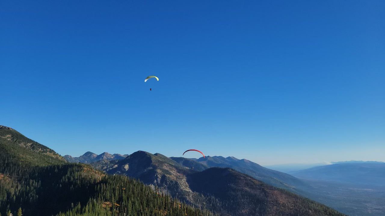
Pilot setting up for final glide at Lunch Lady LZ
Checkerboard Launch
Checkerboard Launch has been used for decades by a handful of Hang Glider pilots and in recent years Paraglider pilots. Checkerboard Launch presents amazing views of the Flathead Valley to the West and views of the Bob Marshall Wilderness to the East. This site has great XC potential for more experienced pilots. The flight from launch to LZ is a 3400’ elevation change. “Sled rides” are usually still 10-15 minute flights. The launch resides in the Flathead National Forest atop a SW facing summit in a clearing that was the result of a forest fire years ago. The launch has been cleared of deadfall and debris about 20 yards from the summit downhill. It is a primitive, not developed launch site. Below the cleared area there are numerous fallen and standing dead trees as well as stumps to watch for.
While the LZ can easily be reached from launch on glide, it is important to monitor altitude and be cautious of getting too low in the bowl after launch. Thermal cycles are often present and the cleared face of the launch ridge can provide a good thermal to gain altitude to get up and out of the bowl. It is easy to get too low in the bowl looking for a thermal and be at risk of not making the LZ.
Risk factors on launch
Standing dead and forest debris below launch. If there is light or no wind on launch, the skill to perform a solid and confident forward launch is necessary. Know when to abort a bad launch or you will end up in the trees.
Getting too low after launch. Know when it's time to head out to the LZ before getting too low and risk getting stuck. It is recommended that pilots begin the glide to Lunch Lady LZ if they are at an elevation below Checkerboard Launch to ensure adequate elevation for landing set up.
No toplanding. The lee side of launch is a very steep mountain face with thick trees. Rotor is usually present behind the launch ridge.
Thermic Conditions. Midday conditions have been known to be very thermic. Pilots with little thermal flying experience should limit themselves to flying in the mornings and evenings, before and after the heat of the day.
Reference Maps for Checkerboard Launch and Lunch Lady LZ